![](/images/other/stat-length.png)
![Trail Walking Le Saix - Montagne d'Aujour - Photo](https://media.geolcdn.com/t/1900/400/2e7276b9-57ac-45f4-9854-1a9eec392654.jpg&format=pjpeg&maxdim=2)
Montagne d'Aujour
nadd73
User GUIDE
![Length](/images/other/stat-length.png)
Length
16.4 km
![Max alt](https://static1.geolcdn.com/siteimages/upload/files/1508320355ic_sort_altitude_max_24dp.png)
Max alt
1804 m
![Uphill gradient](https://static1.geolcdn.com/siteimages/upload/files/1508320355ic_sort_den_pos_24dp.png)
Uphill gradient
1027 m
![Km-Effort](/images/other/stat-length.png)
Km-Effort
30 km
![Min alt](https://static1.geolcdn.com/siteimages/upload/files/1508320355ic_sort_altitude_min_24dp.png)
Min alt
836 m
![Downhill gradient](https://static1.geolcdn.com/siteimages/upload/files/1508320355ic_sort_den_neg_24dp.png)
Downhill gradient
948 m
![Boucle](https://static1.geolcdn.com/siteimages/upload/files/16400158638029165_repeat_loop_refresh_sync_direction_icon.png)
Boucle
No
Creation date :
2020-10-13 06:42:49.322
Updated on :
2020-10-13 19:12:02.248
![Walking](https://static1.geolcdn.com/sitytour/trail-icons/101.png)
5h33
Difficulty : Medium
![Scan this QR Code to open this trail in the SityTrail application](https://capi.geolives.com/qq0zvz2zws4bq2lad0pu/sitytour/trails/2576892/qr.png?size=200)
FREE GPS app for hiking
About
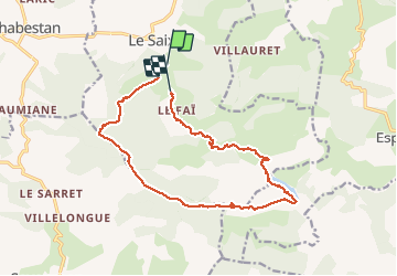
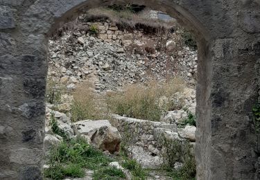
Trail Walking of 16.4 km to be discovered at Provence-Alpes-Côte d'Azur, Hautes-Alpes, Le Saix. This trail is proposed by nadd73.
Description
Veynes, le Saix, se garer au panneau qui insite les touristes à laisser leur voiture.
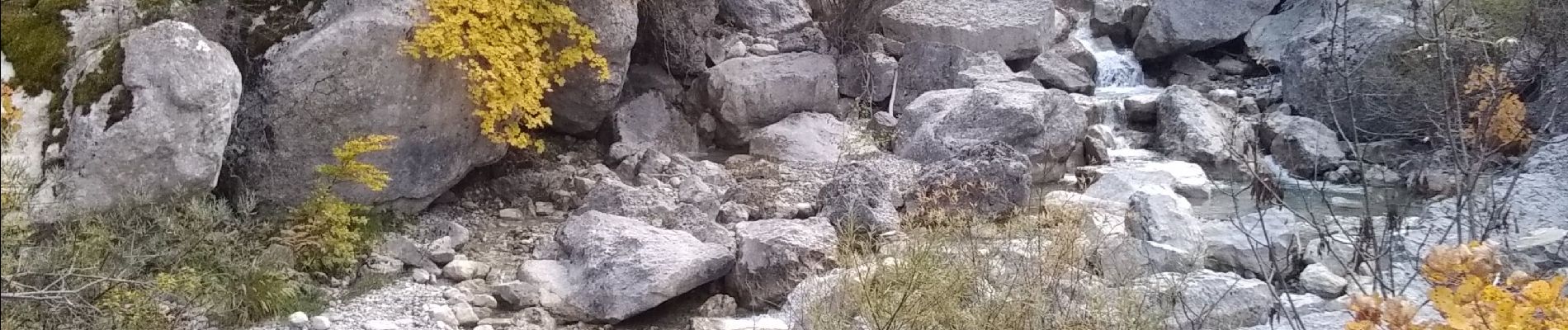
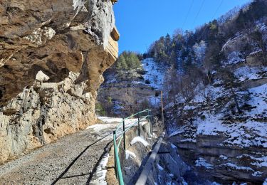
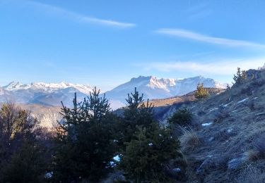
Après le col d'Armande très belle sente sous les falaises. La faille avant d'arriver au sommet est superbe.
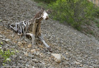
La plaine vers le lac est très agréable.
Positioning
Country:
France
Region :
Provence-Alpes-Côte d'Azur
Department/Province :
Hautes-Alpes
Municipality :
Le Saix
Location:
Unknown
Start:(Dec)
Start:(UTM)
724949 ; 4927891 (31T) N.
Comments
Trails nearby
![Trail Walking Le Saix - R08 La boucle des cascades jaunes - Photo](https://media.geolcdn.com/t/375/260/f26960bc-bc04-44ac-ad0b-fda399df743b.jpg&format=jpg&maxdim=2)
![Walking Walking](https://static1.geolcdn.com/sitytour/trail-icons/101.png)
R08 La boucle des cascades jaunes
Walking
Very easy
(1)
Le Saix,
Provence-Alpes-Côte d'Azur,
Hautes-Alpes,
France
![](/images/other/stat-length.png)
5.5 km | 10.3 km-effort
2h 10min
![](https://static1.geolcdn.com/siteimages/upload/files/16400158638029165_repeat_loop_refresh_sync_direction_icon.png)
Yes
![Trail Walking Le Saix - R07 le fai - Photo](https://media.geolcdn.com/t/375/260/ext.jpg?maxdim=2&url=https%3A%2F%2Fservices.sitytrail.com%2FGeolivesWS%2FDownloadMedia.ashx%3FTrailID%3D890860%26Media%3Dd244d5bc-7fc1-4439-9ce7-046c6af92e70.jpg)
![Walking Walking](https://static1.geolcdn.com/sitytour/trail-icons/101.png)
R07 le fai
Walking
Easy
(4)
Le Saix,
Provence-Alpes-Côte d'Azur,
Hautes-Alpes,
France
![](/images/other/stat-length.png)
5.1 km | 8 km-effort
1h 42min
![](https://static1.geolcdn.com/siteimages/upload/files/16400158638029165_repeat_loop_refresh_sync_direction_icon.png)
Yes
![Trail Walking Le Saix - Lac de Peyssier - Photo](https://media.geolcdn.com/t/375/260/8fccd52b-aa7e-4529-9d46-306413d839a3.jpg&format=jpg&maxdim=2)
![Walking Walking](https://static1.geolcdn.com/sitytour/trail-icons/101.png)
Lac de Peyssier
Walking
Medium
Le Saix,
Provence-Alpes-Côte d'Azur,
Hautes-Alpes,
France
![](/images/other/stat-length.png)
12.8 km | 19.6 km-effort
4h 27min
![](https://static1.geolcdn.com/siteimages/upload/files/16400158638029165_repeat_loop_refresh_sync_direction_icon.png)
Yes
![Trail Walking Le Saix - LE SAIX Abbaye de Claussonne n f - Photo](https://media.geolcdn.com/t/375/260/b6678143-8858-4f6e-a21f-ca2b5f31608c.jpg&format=jpg&maxdim=2)
![Walking Walking](https://static1.geolcdn.com/sitytour/trail-icons/101.png)
LE SAIX Abbaye de Claussonne n f
Walking
Medium
Le Saix,
Provence-Alpes-Côte d'Azur,
Hautes-Alpes,
France
![](/images/other/stat-length.png)
12.5 km | 19.9 km-effort
3h 44min
![](https://static1.geolcdn.com/siteimages/upload/files/16400158638029165_repeat_loop_refresh_sync_direction_icon.png)
Yes
![Trail Running Le Saix - Trail 10 - La Traversée d'Aujour - Photo](https://media.geolcdn.com/t/375/260/7960e4b2-4014-4f4e-a3b8-18621ca82d72.jpg&format=jpg&maxdim=2)
![Running Running](https://static1.geolcdn.com/sitytour/trail-icons/103.png)
Trail 10 - La Traversée d'Aujour
Running
Difficult
Le Saix,
Provence-Alpes-Côte d'Azur,
Hautes-Alpes,
France
![](/images/other/stat-length.png)
16.4 km | 31 km-effort
3h 0min
![](https://static1.geolcdn.com/siteimages/upload/files/16400158638029165_repeat_loop_refresh_sync_direction_icon.png)
Yes
![Trail Running Saint-Auban-d'Oze - Trail 01 - Le Cirque de Villauret - Photo](https://media.geolcdn.com/t/375/260/11438a15-97de-46a3-a3f1-adac73a9fffe.jpg&format=jpg&maxdim=2)
![Running Running](https://static1.geolcdn.com/sitytour/trail-icons/103.png)
Trail 01 - Le Cirque de Villauret
Running
Difficult
Saint-Auban-d'Oze,
Provence-Alpes-Côte d'Azur,
Hautes-Alpes,
France
![](/images/other/stat-length.png)
9.6 km | 19.9 km-effort
2h 0min
![](https://static1.geolcdn.com/siteimages/upload/files/16400158638029165_repeat_loop_refresh_sync_direction_icon.png)
Yes
![Trail Walking Le Saix - R36 - Aujour depuis Clausonne - Photo](https://media.geolcdn.com/t/375/260/ext.jpg?maxdim=2&url=https%3A%2F%2Fservices.sitytrail.com%2FGeolivesWS%2FDownloadMedia.ashx%3FTrailID%3D900901%26Media%3D07eeed14-7ac4-4eb4-8213-2bf0e812ce12.jpg)
![Walking Walking](https://static1.geolcdn.com/sitytour/trail-icons/101.png)
R36 - Aujour depuis Clausonne
Walking
Difficult
Le Saix,
Provence-Alpes-Côte d'Azur,
Hautes-Alpes,
France
![](/images/other/stat-length.png)
11.9 km | 22 km-effort
4h 27min
![](https://static1.geolcdn.com/siteimages/upload/files/16400158638029165_repeat_loop_refresh_sync_direction_icon.png)
Yes
![Trail Mountain bike Le Saix - VTT19 - Le tour d'Aujour - Photo](https://media.geolcdn.com/t/375/260/ext.jpg?maxdim=2&url=https%3A%2F%2Fservices.sitytrail.com%2FGeolivesWS%2FDownloadMedia.ashx%3FTrailID%3D894015%26Media%3D41e434c1-1cd1-4e1f-8ecf-3f42d1205684.jpg)
![Mountain bike Mountain bike](https://static1.geolcdn.com/sitytour/trail-icons/202.png)
VTT19 - Le tour d'Aujour
Mountain bike
Very difficult
Le Saix,
Provence-Alpes-Côte d'Azur,
Hautes-Alpes,
France
![](/images/other/stat-length.png)
24 km | 40 km-effort
2h 25min
![](https://static1.geolcdn.com/siteimages/upload/files/16400158638029165_repeat_loop_refresh_sync_direction_icon.png)
Yes
![Trail Mountain bike Le Saix - VTT18 - Col de Peyssier - Photo](https://media.geolcdn.com/t/375/260/ext.jpg?maxdim=2&url=https%3A%2F%2Fservices.sitytrail.com%2FGeolivesWS%2FDownloadMedia.ashx%3FTrailID%3D894014%26Media%3D41e434c1-1cd1-4e1f-8ecf-3f42d1205684.jpg)
![Mountain bike Mountain bike](https://static1.geolcdn.com/sitytour/trail-icons/202.png)
VTT18 - Col de Peyssier
Mountain bike
Medium
Le Saix,
Provence-Alpes-Côte d'Azur,
Hautes-Alpes,
France
![](/images/other/stat-length.png)
20 km | 32 km-effort
2h 15min
![](https://static1.geolcdn.com/siteimages/upload/files/16400158638029165_repeat_loop_refresh_sync_direction_icon.png)
Yes